Friday, May 11, 2012

Interpreting Geological History - Swift Run

The Swift Run Formation was at least an extra mile hike from the Garth Run Formation and is noted in the map below. This outcrop was a sedimentary conglomerate with graded bedding and Catoctin inclusions. The Catoctin formation contains subareal, flood basalt's that are now greenschist. One of the begging questions on this stop was whether or not the beds are upright or have been overturned. This can be determined by taking the angles of the bedding and the cleavage or foliation. It was determined that the Swift Run outcrop was, in fact, upright, because the angle of the cleavage was steeper than that of the bedding.

Image of Swift Run Formation - green arrow - and the Garth Run Formation - Red pin. Image from Google Earth
Swift Run sits on top of the Grenville basement province but below the Catoctin formation. The primary structures that were noted in this outcrop were graded, hummocky, and cross bedding as well as rip up casts of mud. Foliation was noted as a secondary structure. The predominant rock type was an arkosic sandstone and metamorphosed mudstone. Swift Run is not found in many locations, which suggests that it filled lower valleys at a time of higher relief that was later over-topped by the eruption of basalt's that became the Catoctin.

The breaking up of Rodinia, roughly 600 million years ago, was the driving force for the erupted basalt layers that are now known as the Catoctin. The rifting event caused an area of lower topography or a valley that can be observed in present day Africa. In a very interesting structure lecture not long ago we learned that because of the amount of time it takes for these valley's to fill with sediment they are a sink for fossils - even human remains. 

The measurements taken at Swift Run included primary and secondary structures noted above. 

Pictures here of primary and secondary structures

Thursday, May 10, 2012

Interpreting Geological History - Garth Run


Several weeks ago my structural geology class went on a scheduled three day field trip, which had to be cut short due to what turned out to be four inches of snow. This trip was started just like the others with a rendezvous time of 9 o'clock in the morning at George Mason University in Fairfax. The class filled out the usual insurance paperwork, loaded the vans and started out west towards the Blue Ridge and the Valley and Ridge provinces.

As mentioned above the trip was cut short but we did make four stops that deserve to be analyzed.
The first day of adventure started off a little foggy with a high around 70 degrees Fahrenheit and a lot of enthusiasm.

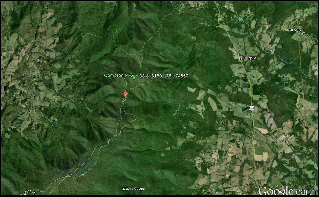
Garth Run is located in a high strain zone of basement rock, which is indicated below in map view.
Garth Run was the most complicated part of the trip, which was frustrating at first because it was so complicated, however this difficult outcrop did open us up to asking the right questions. The predominant rock type was blue quartz which is indicative of the Grenville Basement province. The Grenville was formed during the rifting of the proto-atlantic ocean roughly 1.1 billion years ago. These rocks were then metamorphosed again during the closing of the proto-atlantic ocean and several other tectonic mountain building events. The last tectonic event was after the Mesozoic rifting, which occurred around 210 million years ago.

Picture illustrating the location of Garth Run in Virginia - please note the red pin for placement. Picture from Google Earth.
The Grenville orogeny eroded away which allowed for deposition of lava and other sediments on top of the basement complex. The following tectonic event was termed the Alleghanian which took place around 200 - 300 million years ago. During this event the African and the North American plates were converged on one another which left distinct areas of stress or shear zones. This is why geologist consider Garth Run to be a shear zone. For the non-geologists a shear zone is an area were faulting takes place underground and because it is underground (high pressure) the faults are not brittle but ductile in nature. This usually occurs at depths greater than 15km. Myolonites are distinctive rock types as well as ultramylonites that were present and indicative ductile deformation.

While taking in the structural geology of Garth Run I noticed some foliation, boudinage, joint surfaces with different foliation angles and differential erosion. After taking careful consideration to all of these primary and secondary structures it was determined that this was a very large area of anastomosing. Anastamosing refers to the shape of foliation or braided pattern. In geology what is in the very very small can also be seen in the very very large and thus by looking at the smaller structures like boudinage we can essentially see the larger structures - anastomosing. The boudins are quartz and feldspar while the outer edges are microlithon, which is the axial plane of cleavage. 

Left: Black line indicates the C fabric while the blue line represents the S fabric in the foliation. Right: Same picture as the left however zoomed in more closely to show the two different orientations of foliation near this joint surface. This is indicative of anastomosing. Picture location on the far right courtesy of Jodi Deprizio. 


Wednesday, May 9, 2012

Interpreting Geological History - Veach Gap

The fourth stop on our soon to be cut short trip ended on a Silurian aged sandstone known as Veach Gap. Located on Massanutten Mountain, Veach Gap is part of the George Washington National Forest.This was one of the most interesting stops by far due to its amazing set of six well formed anticlines (and synclines). Please note the location of Veach Gap below as well as the lower relief towards the center indicating a syncline.

The green arrow indicates coordinates of Veach Gap. Image from Google Earth.

The predominant rock type was quartzite and although the climb was steep and jagged the resulting data and experience were worth the bruises and possible poison ivy. The anticlines were the result of the Alleghanian orogeny around 300 million years ago when Pangaea was coming together. When Africa and Ancestral North America converged on one another the surrounding rock was metamorphosed and folded giving use what we have today, a synclinorium. A synclinorium is a vast elongated syncline with its strata further folded into anticlines and synclines. This can be seen on topographic maps of the area especially when viewing the area around Massanutten. 


Picture of Upright and Gently Plunging Fleuty diagram

Use the limb measurements from the two anticlines measured with stereonet software 

Interpreting Geological History - Compton Peak vs. Limber Lost Trail

After one of the longest hikes up hill I have ever been on with my structural geology class I was taken aback by one of the coolest' primary structure I have ever seen, columnar jointing. If you have never seen what this looks like I highly recommend it because it is a reminder at how beautiful nature is even without trying. The map below illustrates the locations of both Limberlost Trail and Compton Peak. These magnificent structures formed during the break up of Rodinia roughly 750 million years ago. Chronologically these are above the Swift Run Formation.

The green arrow with coordinates represents the Limberlost Trail and the basalt columns. Image from Google Earth.


The green arrow with associated coordinates is the location of the Compton Peak basalt columns. Image from Google Earth.
As noted in previous discussions during a rifting period basalt flows to the surface and cools relatively fast and as the basalt losses heat it also starts to contract along the flow surface. Arrest lines are indicative of this and run perpendicular to the surface, which looks stacking of tabular structures. As a result of this cooling process these basalt columns tend to have a polygonal shape with angles that equal a total of 120 degrees. 

The angles of the basalt columns on Limberlost Trail are not equal to 120 degrees, however and must have gone through some type of metamorphic event as noted in the picture below.

Add basalt column picture here

In contrast the basalt columns at Compton Peak showed very little if any deformation. In order to determine this measurements of angles as well as the strike and dip of the joint surfaces were taken.   The data revealed that, in fact, there had been little to no deformation at the Compton Peak location which is interesting since it is only 1.4 miles from the Limberlost Trail site. Most of the angles measured by the class at Compton Peak were at or very close to 120 degrees. If both of these basalt columns were formed during the same geological period, which we are assuming they were, than the Limberlost Trail basalt's underwent deformation relative to Compton Peak. This is very interesting because, again, the distance between these two outcrops is minimal especially on a geological scale.

Add Class Picture Here