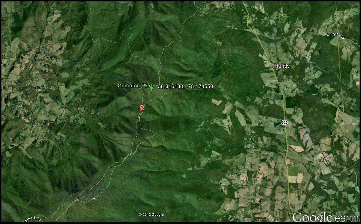
Friday, May 11, 2012

Interpreting Geological History - Swift Run

The Swift Run Formation was at least an extra mile hike from the Garth Run Formation and is noted in the map below. This outcrop was a sedimentary conglomerate with graded bedding and Catoctin inclusions. The Catoctin formation contains subareal, flood basalt's that are now greenschist. One of the begging questions on this stop was whether or not the beds are upright or have been overturned. This can be determined by taking the angles of the bedding and the cleavage or foliation. It was determined that the Swift Run outcrop was, in fact, upright, because the angle of the cleavage was steeper than that of the bedding.

Image of Swift Run Formation - green arrow - and the Garth Run Formation - Red pin. Image from Google Earth
Swift Run sits on top of the Grenville basement province but below the Catoctin formation. The primary structures that were noted in this outcrop were graded, hummocky, and cross bedding as well as rip up casts of mud. Foliation was noted as a secondary structure. The predominant rock type was an arkosic sandstone and metamorphosed mudstone. Swift Run is not found in many locations, which suggests that it filled lower valleys at a time of higher relief that was later over-topped by the eruption of basalt's that became the Catoctin.

The breaking up of Rodinia, roughly 600 million years ago, was the driving force for the erupted basalt layers that are now known as the Catoctin. The rifting event caused an area of lower topography or a valley that can be observed in present day Africa. In a very interesting structure lecture not long ago we learned that because of the amount of time it takes for these valley's to fill with sediment they are a sink for fossils - even human remains. 

The measurements taken at Swift Run included primary and secondary structures noted above. 

Pictures here of primary and secondary structures

Thursday, May 10, 2012

Interpreting Geological History - Garth Run


Several weeks ago my structural geology class went on a scheduled three day field trip, which had to be cut short due to what turned out to be four inches of snow. This trip was started just like the others with a rendezvous time of 9 o'clock in the morning at George Mason University in Fairfax. The class filled out the usual insurance paperwork, loaded the vans and started out west towards the Blue Ridge and the Valley and Ridge provinces.

As mentioned above the trip was cut short but we did make four stops that deserve to be analyzed.
The first day of adventure started off a little foggy with a high around 70 degrees Fahrenheit and a lot of enthusiasm.

Garth Run is located in a high strain zone of basement rock, which is indicated below in map view.
Garth Run was the most complicated part of the trip, which was frustrating at first because it was so complicated, however this difficult outcrop did open us up to asking the right questions. The predominant rock type was blue quartz which is indicative of the Grenville Basement province. The Grenville was formed during the rifting of the proto-atlantic ocean roughly 1.1 billion years ago. These rocks were then metamorphosed again during the closing of the proto-atlantic ocean and several other tectonic mountain building events. The last tectonic event was after the Mesozoic rifting, which occurred around 210 million years ago.

Picture illustrating the location of Garth Run in Virginia - please note the red pin for placement. Picture from Google Earth.
The Grenville orogeny eroded away which allowed for deposition of lava and other sediments on top of the basement complex. The following tectonic event was termed the Alleghanian which took place around 200 - 300 million years ago. During this event the African and the North American plates were converged on one another which left distinct areas of stress or shear zones. This is why geologist consider Garth Run to be a shear zone. For the non-geologists a shear zone is an area were faulting takes place underground and because it is underground (high pressure) the faults are not brittle but ductile in nature. This usually occurs at depths greater than 15km. Myolonites are distinctive rock types as well as ultramylonites that were present and indicative ductile deformation.

While taking in the structural geology of Garth Run I noticed some foliation, boudinage, joint surfaces with different foliation angles and differential erosion. After taking careful consideration to all of these primary and secondary structures it was determined that this was a very large area of anastomosing. Anastamosing refers to the shape of foliation or braided pattern. In geology what is in the very very small can also be seen in the very very large and thus by looking at the smaller structures like boudinage we can essentially see the larger structures - anastomosing. The boudins are quartz and feldspar while the outer edges are microlithon, which is the axial plane of cleavage. 

Left: Black line indicates the C fabric while the blue line represents the S fabric in the foliation. Right: Same picture as the left however zoomed in more closely to show the two different orientations of foliation near this joint surface. This is indicative of anastomosing. Picture location on the far right courtesy of Jodi Deprizio. 


Wednesday, May 9, 2012

Interpreting Geological History - Veach Gap

The fourth stop on our soon to be cut short trip ended on a Silurian aged sandstone known as Veach Gap. Located on Massanutten Mountain, Veach Gap is part of the George Washington National Forest.This was one of the most interesting stops by far due to its amazing set of six well formed anticlines (and synclines). Please note the location of Veach Gap below as well as the lower relief towards the center indicating a syncline.

The green arrow indicates coordinates of Veach Gap. Image from Google Earth.

The predominant rock type was quartzite and although the climb was steep and jagged the resulting data and experience were worth the bruises and possible poison ivy. The anticlines were the result of the Alleghanian orogeny around 300 million years ago when Pangaea was coming together. When Africa and Ancestral North America converged on one another the surrounding rock was metamorphosed and folded giving use what we have today, a synclinorium. A synclinorium is a vast elongated syncline with its strata further folded into anticlines and synclines. This can be seen on topographic maps of the area especially when viewing the area around Massanutten. 


Picture of Upright and Gently Plunging Fleuty diagram

Use the limb measurements from the two anticlines measured with stereonet software 

Interpreting Geological History - Compton Peak vs. Limber Lost Trail

After one of the longest hikes up hill I have ever been on with my structural geology class I was taken aback by one of the coolest' primary structure I have ever seen, columnar jointing. If you have never seen what this looks like I highly recommend it because it is a reminder at how beautiful nature is even without trying. The map below illustrates the locations of both Limberlost Trail and Compton Peak. These magnificent structures formed during the break up of Rodinia roughly 750 million years ago. Chronologically these are above the Swift Run Formation.

The green arrow with coordinates represents the Limberlost Trail and the basalt columns. Image from Google Earth.


The green arrow with associated coordinates is the location of the Compton Peak basalt columns. Image from Google Earth.
As noted in previous discussions during a rifting period basalt flows to the surface and cools relatively fast and as the basalt losses heat it also starts to contract along the flow surface. Arrest lines are indicative of this and run perpendicular to the surface, which looks stacking of tabular structures. As a result of this cooling process these basalt columns tend to have a polygonal shape with angles that equal a total of 120 degrees. 

The angles of the basalt columns on Limberlost Trail are not equal to 120 degrees, however and must have gone through some type of metamorphic event as noted in the picture below.

Add basalt column picture here

In contrast the basalt columns at Compton Peak showed very little if any deformation. In order to determine this measurements of angles as well as the strike and dip of the joint surfaces were taken.   The data revealed that, in fact, there had been little to no deformation at the Compton Peak location which is interesting since it is only 1.4 miles from the Limberlost Trail site. Most of the angles measured by the class at Compton Peak were at or very close to 120 degrees. If both of these basalt columns were formed during the same geological period, which we are assuming they were, than the Limberlost Trail basalt's underwent deformation relative to Compton Peak. This is very interesting because, again, the distance between these two outcrops is minimal especially on a geological scale.

Add Class Picture Here

Thursday, April 19, 2012

Thoughts on Thoroughfare Gap

A few weeks ago my structural geology class went on a four mile hike near a break in Bull Run Mountain known as Thoroughfare Gap (TFG). This area marks the beginning of the Blue Ridge Mountain range and the end of the Piedmont. Between these two ancient mountain belts lay the Culpeper Mesozoic Basin. The day's mission was to take strike and dip measurements of joint sets, veins, and other deformations due to Appalachian Mountain building. Then, from these measurements, determine the orientation of the applied stress. This will be determined from a collection of the class’s data along with stereo-net software.

Important to note: although there was no history lesson given in the sequence of this trip, during the American Civil War, in 1862, this was the location of the Battle of Thoroughfare Gap. 

As an added benefit the class walked the railroad tracks that bisect the gap and came across a Jurassic aged outcrop known as the Waterfall Conglomerate. The large rocks contained in this loosely cemented outcrop are from the Valley and Ridge Province to the west in the Shenandoah Valley. The fascinating idea here is that they were once at the bottom, or the bed load, of a river and are only found in the Culpeper basin (USGS, 2003). The presence of the conglomerate and the gap in Broad Run are indicative of a once high velocity river that, due to its incising, was there before the mountains! Below are pictures taken of the Waterfall Conglomerate on TFG.


Pictures taken of the Waterfall Conglomerate. Note the subangular clast sizes and the reddish brown matrix. Picture taken by Jodi Deprizio   
The day started out at 10:00 am at the back of the loading docks at George Mason University in Fairfax. After the usual paperwork – insurance forms – the class embarked on their journey to Thoroughfare Gap. The day was cloudy with a high of 63 °F with a eesmall chance of rain – 10%. Thankfully, I don’t trust meteorologist and brought my rain gear anyway – this was a good call. It started to drizzle around lunch time when we finally got to the peak and soon thereafter the temperatures dropped.  However, due to the absolutely magnificent view at the top of Bull Run Mountain, overlooking the Culpeper Basin towards the Blue Ridge Anticlinorium, the class didn’t seem to notice the rain.

The view at the top of Bull Run Mountain looking out across the Culpeper Mesozoic Basin. The Blue Ridge Anticlinorium visible in the distance.  

The Chilhowee Group is made up of the Weverton, Harpers, and Antietam Formations respectively. The group originated from one, extremely slow, geological event - erosion of the proto-Appalachian Mountains.  The driving force of this erosional event was the Grenville orogeny and the making of Rodinia, which caused the proto-Appalachians to be uplifted. Rodinia's creation and the resulting collisions with North America and parts of South America resulted in the Grenville Range. It is common for areas of former crustal spreading to become areas of new crustal spreading  because of weakness that already exist in the crust. Much like the way water prefers rock that has already been fragmented, which was discussed in earlier posts regarding Mather Gorge. 

The rifting of Rodinia, roughly 700 Mya, allowed for basalt/magma to be 'squirt' or inserted into newly opened joints and faults. Later, this basalt deposit became the bottom of the Iapetus Ocean. The rifting continued, and eroded sediments from the proto-Appalachian Mountains were deposited on the bottom of the new ocean ultimately creating the three formations. The term used for this by geologist and coastal scientists is passive margin sedimentation, more simply put the transition between oceanic and continental crust. Continental rifting creates new ocean basins, as was happening with the Iapetus Ocean, and as this progresses the ocean basin or floor becomes wider. Remember that basalt is being injected or 'squirt' into areas as the crust is being spread apart.  As the extension continues a mid-oceanic ridge forms and this transition between oceanic (basalt) and continental crust, that was  originally created, is called the passive margin.  


The second tectonic event of interest in this area is the assembly and separation of Pangaea roughly 290 MyaThe making of Pangaea and the closing of the Iapetus Ocean marked the beginning of the Appalachian orogenies. The Appalachian Mountains were formed from many collisions, specifically the Alleghanian/Appalachian orogenies. These were caused by the collision of North America and Africa. At this time Africa was part of a larger continent called Gondwanaland. This event created the much larger, super-continent of Pangaea. Due to the ever changing world another rifting event was initiated, which would eventually form the coast of eastern North America and western Africa as well as the Atlantic Ocean. The separation of the last super-continent.


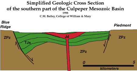
 The break-up of this ancient super-continent resulted in a series of normal fault basins or grabens, which through progressive spreading, became the bottom of the Atlantic Ocean. As discussed before, this spreading allows for magma to be injected or squirt into joints and fractures eventually creating an oceanic basin or chasm. However, not all areas of spreading fulfill a full rifting sequence. The Culpeper Basin is one such failed geologic event. Initially, for spreading to occur, there must be three points of rifting also known as the triple junction above a hotspot. In the case of the Culpeper Basin two of the three points of rifting failed and one continued. Due to the failure of the Culpeper Basin, which is associated with a much larger aulocogen called the Newark Supergroup, Fairfax County is located on the east coast of America and not on the west coast of Africa. Please note diagrams below that illustrate processes for development of Chilhowee Group. 


'Ancient Lands' depicts the ancient mountains stretching from Bull Run Mountain to Front Royal. Please note the chronological order of  the topographical sequences in the right top corner. Picture from brmconservancy.org.

Culpeper Mesozoic Basin Diagram of processes associated with the creation of the Chilhowee Group. Rifting as well as the beginning of an ocean basin. Picture courtesy C.M. Bailey.


As the class started the first two miles up Bull Run Mountain our guide, Aaron Barth a former structural geology student, pointed out sections of the Weverton Formation, and made note that they were dipping off to the east. The Weverton layer was the first to be deposited during the rifting of Rodinia. The phyllitic Harpers Formation, also dipping to the east, was noted along the hike which may have been a lagoon during the making of the Iapetus Ocean. The term phyllitic refers to    one of the main types of continuous cleavage and more specifically has larger sized grains and a soft pearly luster. Geologist use the term cleavage to represent a plan in a rock that allows for splitting, more simply put if a rock were hit by a hammer the break would occur along its cleavage. A picture of the Harpers Formation is below, the second layer of the Chilhowee Group.  

Picture of exposed Harper Formation taken at the beginning of the Thoroughfare Gap Hike. Please note the location map on the side of the picture for better oversight of topography and locality.

After the wonderful view and lunch break the class proceeded onto the next adventure, which consisted of the measuring of joint sets, veins and deformed bedding. This is, hopefully, going to tell us in what orientation the stress was coming from. Below is a picture of the railroad along which Thoroughfare Gap is outcropped. 

Thoroughfare Gap. The railroad tracks (left) and a float rock from the Blue Ridge Basin Province (right) note the blue quartz and how it has been lineated.

Areas of significance while out in the field. There is more than one joint set present and, because of this it resembles a synform. The yellow, red, and black lines represent different joint sets.

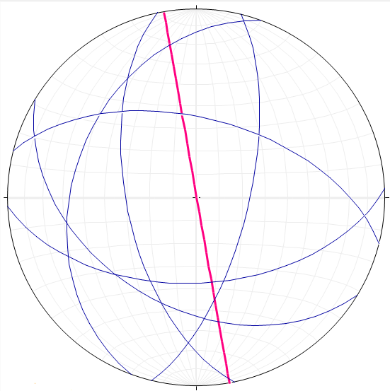
It is now time to answer the question of force/stress orientation by using what is known about the geological history and stereo-net software. 

The arrows are point to possible clusters of joints, or joint sets obtained using
stereo-net software.
There appears to be at least two, possibly three, sets of joints in this outcrop. As seen in the pictures above, some joints don't extend past others that are in a perpendicular to one another. There also seems to be a ~45 degree angle between the longer black joint and the yellow joint set. 

Bedding orientations at TFG which seem to be in a non-horizontal position. 
The bedding planes seem to be in an altered position from original deposition and somewhat parallel to the joint sets. There is also more than one geological event associated with a bedding plane. This area marks the beginning of the Blue Ridge 'overturned' anticlinorium. 

Quartz vein orientations at TFG. Please note the striking similarity to the
bedding planes.
The quartz veins are very similar in orientation to the bedding planes. . . At this time I cannot explain this, however, will be trying to piece this together in the mean time. I would have expected the joint sets and the quartz veins to line up, not the bedding planes. It is possible, however, to achieve this and that is by foliation. It is also important to note that cleavage will form perpendicular to the direction of greatest shortening and all foliation is cleavage but not all cleavage is foliation.

Thus to answer the question, first referenced above, regarding the stress orientations applied to the strata - The longest axis is parallel to the fold axis - which would account for the placement of the quartz veins - the idea is that when the strata was folding the inside was crumpled or pulverized together while the outer part of the fold was pulled apart allowing for pressure solution and precipitates.  


Thursday, March 8, 2012

The mystery uncovered. . .

Several days ago I was explaining structural features that were visible on the class trip to the Billy Goat Trail located in Maryland. The path the class took on the Billy Goat Trail started at the Majors Cabin and proceeded to the south, or downstream collecting data along the way. The measurements that were taken consisted of foliation, bedding, joints, fold hinges and limbs and lamprophyre dikes. Joints are especially important in order to determine whether or not our hypothesis is viable. If there is in fact no fault underneath Mather Gorge then the measurements of all the joints should be in roughly the same orientation.

Mather Gorge on the Billy Goat Trail. The yellow arrows indicate direction of
travel and the yellow start denotes the starting point. 
From the collected data and stereo-net software I will now try and deduce whether or not the reason for the gorge is due to faulting or if it is in fact a non-linear lamprophyre dike.
In the picture below is a structural feature mentioned before known as jointing. By using the software and the orientation of Mather Gorge a comparison is made regarding their proclivity. As seen below the pink line represents the general trend of Mather Gorge and the blue planes represent the average strike and dip of joint measurements taken while in the field. By looking at the picture below (the one with the yellow annotations) we can determine that there is more than one set of joints or faults. It is important to note the perpendicular relationship that the joints outlined in yellow have to one another. As mentioned above if the joint sets are in different orientations there might be an area of faulting under the gorge that is responsible for its formation. Additional information is needed to confirm the hypothesis but this is a good start.

I see at least two sets that run parallel to one another, however because I was unable to climb down and observe the structures for myself I can only assume that there are only two. In the stereo-net diagram below there is more than one joint set and their relationships in regards to Mather Gorge and other joints is irregular. Again, there is insufficient evidence to deny or support our hypothesis.


Large scale joint sets on the Virginia side of the Billy Goat Trail. The yellow
arrows are pointing to a set  of joints parallel to one another. There is another joint set
perpendicular to the longer sets, as shown by the arrows and yellow outlines.


Pink line represents the overall trend of Mather Gorge. The blue planes
 represent the average strike and dip of joints collected by the class. 

The idea here is that if the lamprophyre dikes have been offset it is most likely due to faulting underneath the gorge. It is also, however possible for the offset of the lamprophyre dikes to be due to their initial non-linear orientation and nothing to do with the presence of faults. By graphing the data sets collected from the class the orientation of the dikes can be compared with the general trend of Mather Gorge. Then we can look back at the jointing trends to see if there is any similarity as shown below. When comparing the trend of Mather Gorge to the orientation of the lamprophyre dikes they seem to be almost perpendicular to one another but this alone does not explain the gorge.  When comparing the joint sets to both the trend of the gorge and the orientation of the dikes no significant relationship is observed, as seen below. There is some evidence of possible faulting running parallel to Mather Gorge, which can be seen by looking at the diagrams below, however due to data constraints I am unable to make a definitive conclusion at this time. Can the trend of the gorge be explained by some other geological mechanism?

Lamprophyre dikes - Billy Goat Trail Virginia side - picture
courtesy Callan Bentley.


The pink line represents the overall trend of Mather Gorge. The
Green planes represent the orientation of the lamprophyre dikes.
The pink line represents the overall trend of Mather Gorge. The
Green planes represent the orientation of the lamprophyre dikes. The
blue planes represent the average strike and dip of joints data collected. 

To answer the above mentioned question the orientation and general trend of foliation was plotted on a stereo-net via the stereo-net software. If there is another explanation for the unusually straight nature of this part of the Potomac River it might be noticeable here. Below is a stereo-net that illustrates foliation along Mather Gorge and compares it to the general trend of the gorge. There does seem to be some analogous behavior between the foliations themselves and the trend of Mather Gorge.

The pink line represents the overall trend of Mather Gorge. The orange
planes represent the strike and dip of foliation observed adjacent to the gorge.

Given the information I can not support or deny the presence of a fault or fault sets as the crux of Mather Gorge, however it is possible that faulting has assisted in its orientation. Therefore due to uncertainties the mystery of Mather Gorge prevails.
                                                                     

Sunday, March 4, 2012

More on mountain building events. . .

Now that you have had time to grasp that concept we can move on.

The outer part of the continent is called the continental shelf. A continental shelf is a shallow, seaward-sloping platform that is part of the continent, extending to the continental rise (it's under water). It was somewhere on this continental shelf platform that would be the future home of the Chesapeake and Ohio (to be referred to as C&O Canal) Canal and the Billy Goat Trail. The C & O Canal is notated on the previous post.The reason that this once underwater area is dry and above sea level today is because of a discrete mountain building event.

During the Middle Cambrian to Early Ordovician (~530Mya) was a Volcanic Island Arc named Chopawamsic Terrane that was located off the coast of Ancestral North America. Unfortunately, the volcanic island arc had been drinking and driving and was headed for a head on collision with poor Ancestral North America. The driving mechanism for the movement was the subduction of the more dense oceanic crust underneath the less dense volcanic island arc. This subduction created lava and ash flows along with movement that eventually closed the Iapetus Ocean basin around 460 million years ago. This was not a fast process, however and allowed for volcanic sediments to be accumulated on the ocean basin which will be of importance later in discussion.

Diagram of the oceanic crust being subducted underneath the volcanic island
arc causing the two land masses to collide. Illustration courtesy Callan Bentley.

In the time leading up to this collision an impure sandstone known as graywacke was accumulating on the bottom of the Iapetus Ocean basin. These sediments were deposited, primarily, as graded beds which are usually associated with turbidity currents. Because of the dark color of the beds it has been interpreted that they were most likely formed in a low-oxygen environment, i.e. the deep sea. This is important to remember because graywacke is the original rock type or protolith of the metagraywacke that is along the Billy Goat Trail and in the Washington DC area. The force and eventual strain caused by the collision of these two land masses caused the originally horizontal graded graywacke to metamorphose into metagraywacke or migmatite. Migmatite refers to a rock that has undergone some metamorphism, however cooled before the process was complete. The result is a rock that has both igneous and metamorphic (granite and metagraywacke).

A key characteristic of a rock that has gone through some sort of deformation, as seen in the photo below, is foliation and folding. Another important feature measured on the Billy Goat Trail were joints. These were used to determine the validity of the Mather Gorge hypothesis in that we were suggesting that joints ( i.e. a fault zone or set of faults) alone could explain its presence. The differential deformation that is observed in the metagraywacke all along the trail is evidence for the mentioned tectonic event which, to geologists, is known as the Taconian Orogeny. The term orogeny refers to a mountain building event. Thus when the Chopawamsic Terrane closed the Iapetus Ocean and collided with Ancestral North America the surrounding rock was put under immense pressure/heat which caused the rock to metamorphose and deform. There is still some horizontal graded bedding present that indicates which way was up and this is due to the nature of a turbidity current. In a turbidite, larger grains settle out first followed by smaller grains and thus the larger grains will be deposited at the bottom, hence giving you the rocks original orientation.

Example of jointing. Yellow arrows pointing at two sets of joints
perpendicular to one another.
Graded bedding. Blue arrow pointing at larger sized grains. Blue
 line separates the boundary between fine and coarse grains
 indicating the younging direction (coarse grains represent the
 bottom whereas fine grains represent top).

Example of folding on the Billy Goat Trail. Purple
lines outline the major theme of foliated beds


At this point on our journey we had encountered rocks that were around 460 million years old! What if I told you we found rocks that were roughly 530 million years old? At the edge of Mather Gorge, just before the Potomac gets wider and turns, the class found deposits of a mafic rock called amphibolite. They are given this name because of their unique alligator skin like texture and in this area were large tabular masses. How did these very old, mafic rocks get to be deposited in the area of Billy Goat Trail?

There are two major clues here, the mafic nature of the rock and its age. Since we know that it is older than the Taconian Orogeny and it is mafic (oceanic crust) then we can deduce that it most likely came from the bottom of the Iapetus Ocean. This was possible due to accumulations of graywacke sediments that were scrapped up off of the ocean floor at the head of the subduction zone, otherwise known as an accretionary wedge. Later, when the Taconian island arc collided with Ancestral North America, these sediments were deposited and with them pieces of the oceanic crust. 

As you probably already know there has been more than one tectonic and or mountain building event here on the modern east coast of America. I am bringing this up because as our journey into geologic past progressed we came upon sizable exposure that seemed out of place in the presence of all the metagreywacke. Boudinage is a term used by geologists for structures that form as a response to layer parallel extension (or layer perpendicular flattening) of stiff layers that are surrounded by softer layers (boudin refers to individual these pieces). This is common among highly deformed sequences of rock types of varying strength. A picture of a boudin is posted below. Evidence for the Acadian Orogeny can be seen along the Billy Goat Trail by way of a series of roughly parallel dikes filled in with mafic igneous rocks that have been dated around 360 million years ago. These structure's are called lamprophyre dikes and are going to be very important in our later discussion regarding Mather Gorge and the fault hypothesis. 

The yellow arrows are pointing at amphibolite - note the alligator skin like texture.
Photo was taken at the Billy Goat Trail. 
Illustration of an accretionary wedge. Image courtesy Callan Bentley. 
Example of a Boudin. Note the difference in rock type
between the index and pinky finger. Photo from Luke O'Neal.

It is amazing to me, and hopefully now you, that rocks can tell such a story, and of course that I get to put my hand on something that is over half a BILLION years old. 


The Billy Goat Trail in the eyes of a Geology Student

Introducing the Billy Goat Trail

Last week the George Mason structural geology class, in which I am enrolled, went on one of its first hiking trips of the semester to the Billy Goat Trail. The trail is located on the Maryland side of Great Falls National Park and runs parallel to the Potomac River for 184.5 miles. The predominant rock type exposed along the trail was graywacke or metamorphosed graywacke (metagraywacke). The trail is of great significance to the class because it cuts across many large geologic provinces in the mid - Atlantic and exposes otherwise buried strata to passersby. The exposed strata can then be interpreted by studying the rock type, orientation, size and primary and secondary structures which is an integral part of structural geology. 


While on the trail students were encouraged to measure and record the strike and dip of beds, trend and plunge of folds, and discuss the different deformations in order to interpret the geological history of the area and discrete mountain building events. This was my first time taking such measurements in the field and proved to be a lesson better understood outside of the classroom. Although the first measurements were just that- measurements -as the day progressed they became more than just recorded data. They became a story that consisted of the birth and death of oceans, mountain ranges and super continents.
The class began the trip at ten o'clock in the morning on a Saturday and because of the dreary weather expected many needed at least two cups of coffee for that extra kick of brain power. Luckily before the class set out on our journey into geologic past there was a stop at the restrooms which after two cups of java was much, much needed. It was roughly fifty degrees and partly sunny at first but within thirty minutes the clouds started to accumulate in the sky and they were accompanied by a drop in temperatures. At first I was dressed appropriately for the weather with a proper rain coat compliments of Callan Bentley and synthetic pants but when it started to rain there was a sudden drop in temperatures that I was not prepared for.  


At the start of the voyage we were briefly educated about the unique history of the Billy Goat Trail and the Chesapeake and Ohio Canal. This was extremely interesting to me because I was unfamiliar with the history of the area. After the lesson it was time to venture into geologic past and embark on our true purpose: discerning whether or not Mather Gorge was the product of a fault or series of faults beneath the Potomac River. Faults tend to weaken the rock around them and cause them to break apart due to large amounts of stress and or strain. 


A little on Mather Gorge:


Below is a satellite image of Mather Gorge at Great Falls which illustrates both the narrowing and straight trend of the otherwise wide, meandering Potomac River. The gorge is roughly 6.5 miles long and returns to meandering almost as abruptly as it stopped. Flowing water is very powerful, however it is always searching for a weak point or a way to use less energy to achieve the same task. 
This is the mechanism driving the idea that a fault or series of faults could be present under the river. When the river was down-cutting it located weak, crushed up rock that is analogous with a fault zone and this zone or area of weakness essentially controlled the course of the river. Therefore, if there is an area of weakness due to a fault line underneath Mather Gorge it would seem logical that the Potomac would follow its path rather than try to cut into the much stronger metagraywacke (metamorphosed sandstone that contains mud)  that surrounds the river. 


Note the pink arrows pointing at the abrupt beginning
 and ending of Mather Gorge


In the beginning of the expedition many of the students were absolutely lost. Even though many had acquired a wealth of knowledge inside the classroom, few knew what to do with it. After a quick lecture and Brunton compasses in hand the class embarked on their first real experience measuring folds, foliation, bedding, joints and dikes. But more on this later, first it is important to understand the geology and diagenesis in this area before moving on. 


It all started . . . . a long, long, geologically long time ago. The time was roughly 510 million years ago during the late Cambrian and there lived an ancient ocean called Iapetus (named after Atlas's father) that surrounded Ancestral North America

The pink arrows are pointing to (from left to right) present day Chesapeake & Ohio
Canal National Historical Park, Iapetus Ocean and Chopawamsic Terrace respectively.

After the break up of Rodinia, another super-continent in Earth's history, Ancestral North America was traveling in a north west direction and was oriented much differently than it is today. In order to give you a better idea as to how different, you would need to rotate modern North America 90 degrees to the south, that is, today's east coast was situated along the south coast.