Thursday, March 8, 2012

The mystery uncovered. . .

Several days ago I was explaining structural features that were visible on the class trip to the Billy Goat Trail located in Maryland. The path the class took on the Billy Goat Trail started at the Majors Cabin and proceeded to the south, or downstream collecting data along the way. The measurements that were taken consisted of foliation, bedding, joints, fold hinges and limbs and lamprophyre dikes. Joints are especially important in order to determine whether or not our hypothesis is viable. If there is in fact no fault underneath Mather Gorge then the measurements of all the joints should be in roughly the same orientation.

Mather Gorge on the Billy Goat Trail. The yellow arrows indicate direction of
travel and the yellow start denotes the starting point. 
From the collected data and stereo-net software I will now try and deduce whether or not the reason for the gorge is due to faulting or if it is in fact a non-linear lamprophyre dike.
In the picture below is a structural feature mentioned before known as jointing. By using the software and the orientation of Mather Gorge a comparison is made regarding their proclivity. As seen below the pink line represents the general trend of Mather Gorge and the blue planes represent the average strike and dip of joint measurements taken while in the field. By looking at the picture below (the one with the yellow annotations) we can determine that there is more than one set of joints or faults. It is important to note the perpendicular relationship that the joints outlined in yellow have to one another. As mentioned above if the joint sets are in different orientations there might be an area of faulting under the gorge that is responsible for its formation. Additional information is needed to confirm the hypothesis but this is a good start.

I see at least two sets that run parallel to one another, however because I was unable to climb down and observe the structures for myself I can only assume that there are only two. In the stereo-net diagram below there is more than one joint set and their relationships in regards to Mather Gorge and other joints is irregular. Again, there is insufficient evidence to deny or support our hypothesis.


Large scale joint sets on the Virginia side of the Billy Goat Trail. The yellow
arrows are pointing to a set  of joints parallel to one another. There is another joint set
perpendicular to the longer sets, as shown by the arrows and yellow outlines.


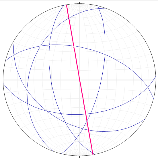
Pink line represents the overall trend of Mather Gorge. The blue planes
 represent the average strike and dip of joints collected by the class. 

The idea here is that if the lamprophyre dikes have been offset it is most likely due to faulting underneath the gorge. It is also, however possible for the offset of the lamprophyre dikes to be due to their initial non-linear orientation and nothing to do with the presence of faults. By graphing the data sets collected from the class the orientation of the dikes can be compared with the general trend of Mather Gorge. Then we can look back at the jointing trends to see if there is any similarity as shown below. When comparing the trend of Mather Gorge to the orientation of the lamprophyre dikes they seem to be almost perpendicular to one another but this alone does not explain the gorge.  When comparing the joint sets to both the trend of the gorge and the orientation of the dikes no significant relationship is observed, as seen below. There is some evidence of possible faulting running parallel to Mather Gorge, which can be seen by looking at the diagrams below, however due to data constraints I am unable to make a definitive conclusion at this time. Can the trend of the gorge be explained by some other geological mechanism?

Lamprophyre dikes - Billy Goat Trail Virginia side - picture
courtesy Callan Bentley.


The pink line represents the overall trend of Mather Gorge. The
Green planes represent the orientation of the lamprophyre dikes.
The pink line represents the overall trend of Mather Gorge. The
Green planes represent the orientation of the lamprophyre dikes. The
blue planes represent the average strike and dip of joints data collected. 

To answer the above mentioned question the orientation and general trend of foliation was plotted on a stereo-net via the stereo-net software. If there is another explanation for the unusually straight nature of this part of the Potomac River it might be noticeable here. Below is a stereo-net that illustrates foliation along Mather Gorge and compares it to the general trend of the gorge. There does seem to be some analogous behavior between the foliations themselves and the trend of Mather Gorge.

The pink line represents the overall trend of Mather Gorge. The orange
planes represent the strike and dip of foliation observed adjacent to the gorge.

Given the information I can not support or deny the presence of a fault or fault sets as the crux of Mather Gorge, however it is possible that faulting has assisted in its orientation. Therefore due to uncertainties the mystery of Mather Gorge prevails.
                                                                     

Sunday, March 4, 2012

More on mountain building events. . .

Now that you have had time to grasp that concept we can move on.

The outer part of the continent is called the continental shelf. A continental shelf is a shallow, seaward-sloping platform that is part of the continent, extending to the continental rise (it's under water). It was somewhere on this continental shelf platform that would be the future home of the Chesapeake and Ohio (to be referred to as C&O Canal) Canal and the Billy Goat Trail. The C & O Canal is notated on the previous post.The reason that this once underwater area is dry and above sea level today is because of a discrete mountain building event.

During the Middle Cambrian to Early Ordovician (~530Mya) was a Volcanic Island Arc named Chopawamsic Terrane that was located off the coast of Ancestral North America. Unfortunately, the volcanic island arc had been drinking and driving and was headed for a head on collision with poor Ancestral North America. The driving mechanism for the movement was the subduction of the more dense oceanic crust underneath the less dense volcanic island arc. This subduction created lava and ash flows along with movement that eventually closed the Iapetus Ocean basin around 460 million years ago. This was not a fast process, however and allowed for volcanic sediments to be accumulated on the ocean basin which will be of importance later in discussion.

Diagram of the oceanic crust being subducted underneath the volcanic island
arc causing the two land masses to collide. Illustration courtesy Callan Bentley.

In the time leading up to this collision an impure sandstone known as graywacke was accumulating on the bottom of the Iapetus Ocean basin. These sediments were deposited, primarily, as graded beds which are usually associated with turbidity currents. Because of the dark color of the beds it has been interpreted that they were most likely formed in a low-oxygen environment, i.e. the deep sea. This is important to remember because graywacke is the original rock type or protolith of the metagraywacke that is along the Billy Goat Trail and in the Washington DC area. The force and eventual strain caused by the collision of these two land masses caused the originally horizontal graded graywacke to metamorphose into metagraywacke or migmatite. Migmatite refers to a rock that has undergone some metamorphism, however cooled before the process was complete. The result is a rock that has both igneous and metamorphic (granite and metagraywacke).

A key characteristic of a rock that has gone through some sort of deformation, as seen in the photo below, is foliation and folding. Another important feature measured on the Billy Goat Trail were joints. These were used to determine the validity of the Mather Gorge hypothesis in that we were suggesting that joints ( i.e. a fault zone or set of faults) alone could explain its presence. The differential deformation that is observed in the metagraywacke all along the trail is evidence for the mentioned tectonic event which, to geologists, is known as the Taconian Orogeny. The term orogeny refers to a mountain building event. Thus when the Chopawamsic Terrane closed the Iapetus Ocean and collided with Ancestral North America the surrounding rock was put under immense pressure/heat which caused the rock to metamorphose and deform. There is still some horizontal graded bedding present that indicates which way was up and this is due to the nature of a turbidity current. In a turbidite, larger grains settle out first followed by smaller grains and thus the larger grains will be deposited at the bottom, hence giving you the rocks original orientation.

Example of jointing. Yellow arrows pointing at two sets of joints
perpendicular to one another.
Graded bedding. Blue arrow pointing at larger sized grains. Blue
 line separates the boundary between fine and coarse grains
 indicating the younging direction (coarse grains represent the
 bottom whereas fine grains represent top).

Example of folding on the Billy Goat Trail. Purple
lines outline the major theme of foliated beds


At this point on our journey we had encountered rocks that were around 460 million years old! What if I told you we found rocks that were roughly 530 million years old? At the edge of Mather Gorge, just before the Potomac gets wider and turns, the class found deposits of a mafic rock called amphibolite. They are given this name because of their unique alligator skin like texture and in this area were large tabular masses. How did these very old, mafic rocks get to be deposited in the area of Billy Goat Trail?

There are two major clues here, the mafic nature of the rock and its age. Since we know that it is older than the Taconian Orogeny and it is mafic (oceanic crust) then we can deduce that it most likely came from the bottom of the Iapetus Ocean. This was possible due to accumulations of graywacke sediments that were scrapped up off of the ocean floor at the head of the subduction zone, otherwise known as an accretionary wedge. Later, when the Taconian island arc collided with Ancestral North America, these sediments were deposited and with them pieces of the oceanic crust. 

As you probably already know there has been more than one tectonic and or mountain building event here on the modern east coast of America. I am bringing this up because as our journey into geologic past progressed we came upon sizable exposure that seemed out of place in the presence of all the metagreywacke. Boudinage is a term used by geologists for structures that form as a response to layer parallel extension (or layer perpendicular flattening) of stiff layers that are surrounded by softer layers (boudin refers to individual these pieces). This is common among highly deformed sequences of rock types of varying strength. A picture of a boudin is posted below. Evidence for the Acadian Orogeny can be seen along the Billy Goat Trail by way of a series of roughly parallel dikes filled in with mafic igneous rocks that have been dated around 360 million years ago. These structure's are called lamprophyre dikes and are going to be very important in our later discussion regarding Mather Gorge and the fault hypothesis. 

The yellow arrows are pointing at amphibolite - note the alligator skin like texture.
Photo was taken at the Billy Goat Trail. 
Illustration of an accretionary wedge. Image courtesy Callan Bentley. 
Example of a Boudin. Note the difference in rock type
between the index and pinky finger. Photo from Luke O'Neal.

It is amazing to me, and hopefully now you, that rocks can tell such a story, and of course that I get to put my hand on something that is over half a BILLION years old. 


The Billy Goat Trail in the eyes of a Geology Student

Introducing the Billy Goat Trail

Last week the George Mason structural geology class, in which I am enrolled, went on one of its first hiking trips of the semester to the Billy Goat Trail. The trail is located on the Maryland side of Great Falls National Park and runs parallel to the Potomac River for 184.5 miles. The predominant rock type exposed along the trail was graywacke or metamorphosed graywacke (metagraywacke). The trail is of great significance to the class because it cuts across many large geologic provinces in the mid - Atlantic and exposes otherwise buried strata to passersby. The exposed strata can then be interpreted by studying the rock type, orientation, size and primary and secondary structures which is an integral part of structural geology. 


While on the trail students were encouraged to measure and record the strike and dip of beds, trend and plunge of folds, and discuss the different deformations in order to interpret the geological history of the area and discrete mountain building events. This was my first time taking such measurements in the field and proved to be a lesson better understood outside of the classroom. Although the first measurements were just that- measurements -as the day progressed they became more than just recorded data. They became a story that consisted of the birth and death of oceans, mountain ranges and super continents.
The class began the trip at ten o'clock in the morning on a Saturday and because of the dreary weather expected many needed at least two cups of coffee for that extra kick of brain power. Luckily before the class set out on our journey into geologic past there was a stop at the restrooms which after two cups of java was much, much needed. It was roughly fifty degrees and partly sunny at first but within thirty minutes the clouds started to accumulate in the sky and they were accompanied by a drop in temperatures. At first I was dressed appropriately for the weather with a proper rain coat compliments of Callan Bentley and synthetic pants but when it started to rain there was a sudden drop in temperatures that I was not prepared for.  


At the start of the voyage we were briefly educated about the unique history of the Billy Goat Trail and the Chesapeake and Ohio Canal. This was extremely interesting to me because I was unfamiliar with the history of the area. After the lesson it was time to venture into geologic past and embark on our true purpose: discerning whether or not Mather Gorge was the product of a fault or series of faults beneath the Potomac River. Faults tend to weaken the rock around them and cause them to break apart due to large amounts of stress and or strain. 


A little on Mather Gorge:


Below is a satellite image of Mather Gorge at Great Falls which illustrates both the narrowing and straight trend of the otherwise wide, meandering Potomac River. The gorge is roughly 6.5 miles long and returns to meandering almost as abruptly as it stopped. Flowing water is very powerful, however it is always searching for a weak point or a way to use less energy to achieve the same task. 
This is the mechanism driving the idea that a fault or series of faults could be present under the river. When the river was down-cutting it located weak, crushed up rock that is analogous with a fault zone and this zone or area of weakness essentially controlled the course of the river. Therefore, if there is an area of weakness due to a fault line underneath Mather Gorge it would seem logical that the Potomac would follow its path rather than try to cut into the much stronger metagraywacke (metamorphosed sandstone that contains mud)  that surrounds the river. 


Note the pink arrows pointing at the abrupt beginning
 and ending of Mather Gorge


In the beginning of the expedition many of the students were absolutely lost. Even though many had acquired a wealth of knowledge inside the classroom, few knew what to do with it. After a quick lecture and Brunton compasses in hand the class embarked on their first real experience measuring folds, foliation, bedding, joints and dikes. But more on this later, first it is important to understand the geology and diagenesis in this area before moving on. 


It all started . . . . a long, long, geologically long time ago. The time was roughly 510 million years ago during the late Cambrian and there lived an ancient ocean called Iapetus (named after Atlas's father) that surrounded Ancestral North America

The pink arrows are pointing to (from left to right) present day Chesapeake & Ohio
Canal National Historical Park, Iapetus Ocean and Chopawamsic Terrace respectively.

After the break up of Rodinia, another super-continent in Earth's history, Ancestral North America was traveling in a north west direction and was oriented much differently than it is today. In order to give you a better idea as to how different, you would need to rotate modern North America 90 degrees to the south, that is, today's east coast was situated along the south coast.